

Using Technology
Maintaining Your Park
JUMP TO:


MORE MAINTAINING SECTIONS:
TAKING YOUR PARK ONLINE
Education, Record Keeping & Navigation
Whether for your visitors or for your staff and volunteers, investing in some online tools can help you manage your park and promote good outdoor activities. Many visitors will have access to a smartphone, and it’s easier than ever to share important resources with your team to make maintenance more efficient.
Technology for Education
QR Codes on Signs and Online Guided Walks
Interpretive signs are great, but the amount of information you can fit on them is limited. Plus, information can change over time, requiring sign replacement.
You can simplify your sign requirements by adding QR codes to smaller signs strategically placed on trails. These QR codes take users to websites, or even online documents and self-led tours, that they can then use to find out more about an area.
QR codes can be useful for directing users to online forms where they can sign up as volunteers, as donors, or for newsletters. Use your codes to direct visitors to learn about nature, conservation, or what’s happening in their public use areas.
If you have a budget to invest in an app, you can direct users to download your park and area information to their phone through which you can send them reminders, notifications, and facts about conservation.
Wayfinding & Trails
Online Maps, Offline Maps & Accessible Website Information About Your Park
These days, many visitors like to be prepared for their adventure before they arrive, from parking, amenities that exist at the site, information about trails, whether a public space is pet friendly, and how accessible or difficult the trails and activities might be.
The more information you provide, the better prepared your visitors will be to be good outdoor citizens!
Ensure you have easily accessible information on your website about park amenities, that the information is easily searchable, and includes links to good map information. Especially for those parks and conservation areas that do not have a visitor information or interpretive centre, an informative website can act like a welcoming committee.
Once visitors are at the park, make sure that they can take the necessary information with them as they travel through by providing downloadable maps that are easily accessed on smartphones.
By providing information for offline use, you guard against spotty cell service and still offer users information when they need it.

Treat your conservation area, trail system, or urban park as though they are a draw for visitors who have never been there! Provide thorough information to help your visitors find what they need, whether it’s their first time in your community or they are longtime residents. Keep your website information current, and update your online search engine maps with detailed information about your park.
GIS Technology for Your Park Amenities
Geographic Information Systems (GIS) can be somewhat complicated to get started with, but once created can be incredibly valuable management tools for parks and conservation areas.
Whether public or internal, GIS can provide current, relevant information to those who need it. Many communities use GIS to manage aspects of administration, including ASUPCA members. The following are just two examples of how GIS can organize your resources more efficiently.

Little Red River Park covers 1200 acres and has an extensive trail network, created over the years by hikers, bikers, and skiers. Many of the trails are “desire” lines or trails meaning that they were created by use rather than through purposeful planning. Helpful wayfinding signs are strategically positioned to guide travelers, but the city parks department has also used GIS to create an interactive park map that visitors can use to get a bird’s eye view of the trail network on a satellite map, and plan their trip accordingly. The online map includes the amenities spread throughout the park, all the information a new or returning visitor could need!
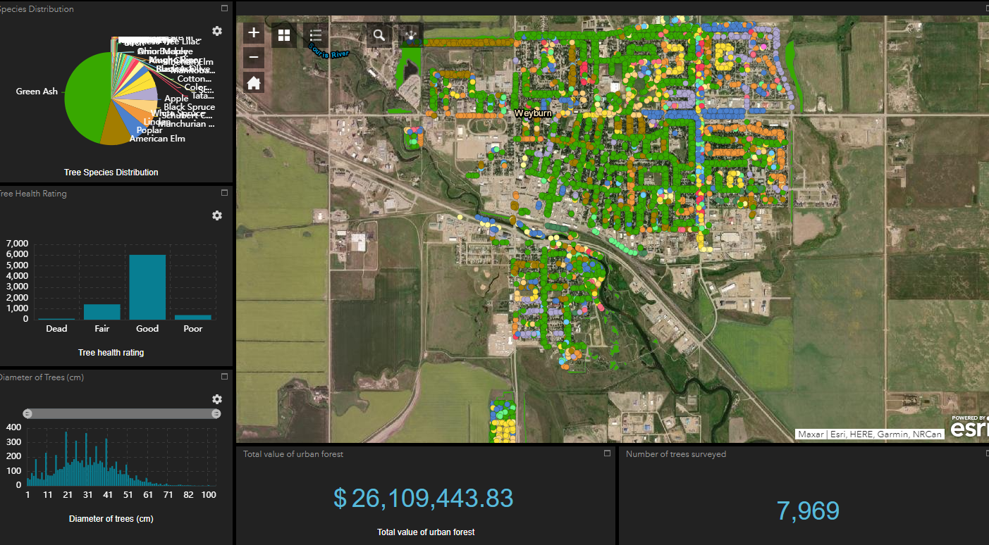
The City of Weyburn parks department undertook an extensive tree inventory process in 2021, and as part of the project, a GIS was created to help the department manage the health and maintenance of the city’s tree canopy. The GIS records a history of each tree owned by the city and provides a connection between requests that come to the office, and the maintenance staff tasked with tree care, watering, pruning and replacement. The GIS is also a helpful tool for monitoring the impact of Dutch Elm Disease over time, as well as other invasive and damaging pests and diseases.
Record Keeping
Choose a record keeping method and keep it current.
Park and conservation area building spans generations, and those in charge of care and maintenance in the future will thank you for creating a solid record keeping process.
Using technology to help file information and resources for future use, including service level agreements, sponsorship contracts, grant funders and terms, suppliers, consultants, and more is worth the investment of time and effort. As staff and volunteers change over time, a current resource library and guiding templates for organizing information will be appreciated!

CHECKLIST ITEMS
Review your current online resources for visitors and residents to see if there are ways you can take your park or conservation area information online!
Explore the benefits of implementing a simple GIS to help you manage community assets. Reach out to communities using GIS to find out how they use and manage the platform for their needs.
Create the basis for your record library and start organizing current and historical information about your park system or conservation area. Use a platform easily accessible by multiple users.
Picnic Pavillion Little Red River Park, Prince Albert